7 June 2018, Thursday
I woke up this morning at 6am, all ready and excited for the hike to Trolltunga (click here). I checked the weather forecast and it was a chilly 8 degrees Celsius at the moment, with the temperature expected to hit a nice 17 degrees at noon time.
I had booked a guided tour with Trolltunga Active (click here) and a free shuttle bus was provided. It took us from Trolltunga Hotel to Skjeggedal, the starting point for the trek, and we arrived at 7:35am. If you’re thinking of doing the trek on your own without a guide, you can only do so during the main hiking season between 15 June and 15 September. During that time, there will be a public bus service running from Odda to Skjeggedal and it costs 250 Kr for a two-way trip. You can also drive and park at Skjeggedal. The parking fee is 500 Kr per day.

There were about 13 of us joining the tour. Over the course of the day, I made friends with my fellow travellers Mitch, Abby, Trina and Chris. After all the participants had arrived, we went to the Trolltunga Active office, where I borrowed a trekking pole from them. Everyone then used the toilet before our three guides, Lina, Mikaela and Samuel gave us a final briefing.
According to one of the signs that I saw, the total hiking distance was 22km, with an ascent of 700m. The duration required was 10 to 12 hours. However, a detailed topographic map of the area showed that the distance to Trolltunga was 14km one-way, which meant that a return trip would actually be 28km altogether. Our guides also told us that we would need to reach the 7km mark before 1pm. If we didn’t meet the cut-off timing, it meant that our pace was too slow and we would have to turn back. This is because darkness sets in early during the non-summer months (after 15 August and before 15 June) and it would not be safe to proceed to Trolltunga and risk coming back in the dark.


I felt good physically and was raring to go. Looking around, everyone seemed very fit as well so I was confident that we would all make the cut-off timing. Finally, we set off at 7:55am. Trolltunga, here we come!


We started at an elevation of about 450m. The first 4km were the steepest for the whole trek, ascending to about 850m. It took us about 55 minutes to complete the first 1km, with two short breaks in between. There was plenty of vegetation cover to shield us from the sun.


At about 9:05am, we reached the first water refill point. The water from the mountain was so clean that you could drink it straight from the source.


From that point on, the terrain was undulating but not that tough. However, the vegetation cover reduced greatly and it was mainly small shrubs and grass. With direct exposure to the sun, it was much hotter now so I converted my trekking pants into a pair of bermudas by removed the leg sleeves.


At about 10:10am, we encountered some snow and ice patches. We were lucky that it had been very warm for the past two weeks, so most of the snow had already melted. Otherwise, it would have been much harder to trudge through the snow or walk on the slippery rocks. The landscape here reminded me a little of the Mt. Kailash trek in Tibet, but thankfully, without the high altitude and breathlessness.


At 10:26am, we reached the 7km mark, well ahead of the cut-off time. Good job, everyone! This meant that we had taken about 2.5 hours to cover the first 7km and we were halfway to Trolltunga. Based on our current pace, we should finish the entire hike in around 10 to 11 hours.
At this point, the area was very open and it was actually quite hard to make out the trail. This is why it is good to join a tour so that you don’t get lost. In any case, if you’re doing the hike on your own, do look out for the red “T” signs painted on the rocks to guide you.


We then had to make our way past a snow field. The snow was not very deep so it wasn’t too tough to manage. The sun had hidden behind some cloud cover so the air was noticeably colder here. A small lake had formed from the melting ice and the water was so clear. It was very tempting to scoop some to drink it.


At about 10:55am, we stopped for a lunch break for about 25 minutes. I munched on my ham and cheese sandwich and banana while taking in the marvellous view in front of me.


Moving on from the lunch spot, we soon reached an open area where we had our first glimpse of lake Ringedalsvatnet below. The 7-square-kilometre lake is the main reservoir for a hydroelectric power station in the nearby town of Tyssedal. It provided electricity for the power-intensive industries in Odda, when it was still an industrial town. The deep blue waters of the lake were simply stunning and I spent a good amount of time taking it all in. At that moment, I really felt that life was good.


After that, we continued our journey, making our way past some wet snow and mud before reaching our final water refill point at about 1pm. Our guide told us to fill our bottles here because from here onwards, the water would not be safe to drink anymore as we were getting closer to Trolltunga and many people camped around the area, thereby polluting the water supply.


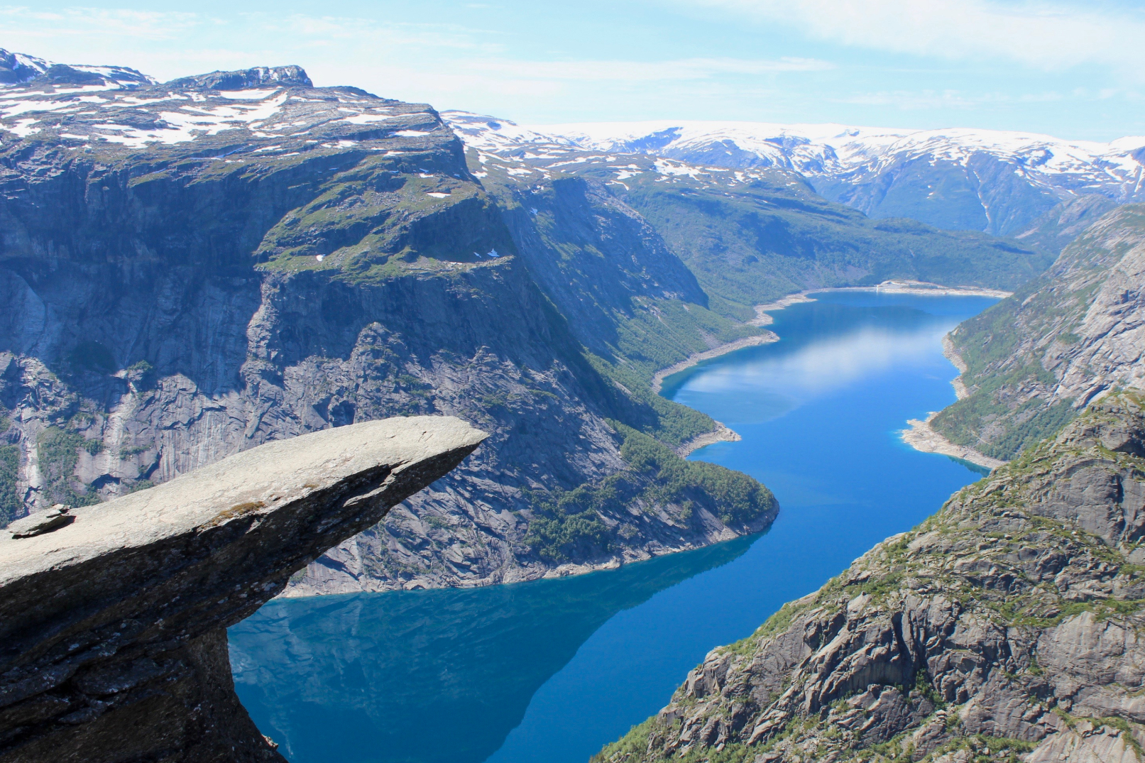
Finally, at about 1:40pm, we arrived at Trolltunga! We had taken almost six hours to get here. Trolltunga means “Troll’s tongue” and it is arguably Norway’s most spectacular rock formation. The elevation at Trolltunga is 1,180m and it hovers 700m above lake Ringedalsvatnet. I had seen pictures of it on the Internet but nothing beat being there in person and seeing it with my own eyes. Trolltunga was exactly like how I imagined it to be. It was surreal.

It was not very crowded when we arrived. We formed a line and took turns to go on the “tongue” so everyone had plenty of time to get their photos. The “tongue” jutted out from the cliff and I felt like I was walking on a precarious piece of rock hanging in mid-air. It wasn’t as scary as Preikestolen but it was still quite unnerving when I walked close to the edge.


After the first round of pictures, we were told that one of our guides, Samuel, would be abseiling a short way down the adjoining cliff so he could take photos of us from a lower angle, which otherwise wouldn’t be possible. One of our group members volunteered his camera for Samuel to shoot with. It was a pleasant surprise to have this value-added service, and Trolltunga Active didn’t even charge us for it. That’s one of the perks for joining a guided tour!
So we went for another round of individual photos, followed by a nice group shot. It was a pity that the sun was behind us so our faces were in shadow, but nevertheless, the photos still turned out quite awesome.


Finally, at 3:05pm, we left Trolltunga and headed back. Having accomplished our mission, we were still feeling quite high and in good spirits. I started chatting more with my fellow adventurers and sharing travel stories.
With the sun high up in the sky, the return trek was quite tough as it got really hot and there was no vegetation cover to provide shade. Even with my light load, I could feel my legs getting heavier with every step I took.


At about 6:50pm, we had reached the last section and we had two options to get to the finishing point. We chose to take the winding road down instead of taking the steeper route through the forest. It was easier on the knees but it was longer and I felt it was more tiring. Nevertheless, we persisted and eventually reached Skjeggedal at 7:28pm.


After making our way back to Trolltunga Hotel exhausted but elated, we planned to have our dinner at the hotel. However, there was already a large group of people in the restaurant and it would take at least an hour for us to be served. That didn’t sound good to a bunch of ravishing folks who had just completed a hike to Trolltunga, so a few of us decided to head to town instead.
We found a restaurant serving Italian food and I ordered a plate of spaghetti bolognese and a bottle of Coke (219 Kr / S$37.43). Food never tasted so good!

After dinner, we went back to the hotel to find that the big group had since left. We then continued our party by having drinks, and I ordered a bottle of Trolltunga Beer (110 Kr / S$18.80) to celebrate the occasion. It was a fantastic end to the day.


It took us 11.5 hours to trek the 28km to Trolltunga and back, what an achievement! I must say it was quite tough because of the long distance, but thankfully, the wonderful guides and the great bunch of trekking mates made the experience so much more fun and memorable. Even though it was quite pricey (1,100 Kr / S$192.73), I feel it was money well spent joining the tour with Trolltunga Active because I don’t think I would have enjoyed it as much had I done it solo.
We were also blessed with incredibly good weather for this time of the year, where it wasn’t too hot or cold, and there wasn’t much snow or mud to impede our progress. The steep cliffs, the deep blue waters of the lake, and of course, the troll’s tongue itself were amazing to behold, and it was one of the most beautiful hikes I had ever done. Trolltunga was everything I imagined it to be, and more. Definitely recommend everyone to do it when visiting Norway!