Day 5: 14 May 2017, Sunday
It was a chilly 5 degrees Celsius when we woke up at around 7am this morning. The weather forecast showed a 30% chance of rain at 10am, 70% at 11am and 90% at noon, so we were eager to get the day started before the rain set in. Our main agenda today was to complete a hike at Algonquin Provincial Park.

Algonquin Provincial Park is generally divided into two areas – the backcountry and the developed areas. The vast interior is the backcountry and it is only accessible by foot or canoe. It has over 140km of backpacking trails and over 2,000km of canoe routes. I will love to explore the backcountry but it will require a lot more time and it is much more challenging to navigate. The developed areas are along the Highway 60 corridor and peripheral campgrounds, and they are much more accessible.
Highway 60 is the main road that cuts through the southwestern part of the park and it is bookmarked at both ends by the West Gate and East Gate. Distances are calculated with respect to the West Gate, which is km 0. The Highway 60 corridor runs for 56km altogether, therefore, the East Gate is km 56.
Scattered along the 56km of the Highway 60 corridor are a total of 15 Interpretive Walking Trails. The shortest trail is only 1.0km while the longest trail is 10.8km long. They are graded into Easy, Moderate and Difficult levels. There is something for everyone and you will be able to find a trail that suits your physical ability quite easily.
To enjoy the use of Algonquin Provincial Park, you will need to purchase a vehicle permit. It can be obtained at the East and West Gate, and also at the Visitor Centre at km 43. A day permit allows you to be in the park until 10pm of the date of issue. You will need to display the permit prominently on your vehicle dashboard or risk a CAD$30 fine.


When we arrived at the West Gate at 7:40am, the shop was not open but there was a ticket machine where we could purchase the vehicle permit. It cost CAD$17 + 13% tax, or CAD$19.21 after tax (S$19.90). Affixed to the machine was a notice that informed that the Whiskey Rapids trail was closed due to flooding. Flooding is quite common during spring time because the ice melts during this period and there is heavier rainfall too. So, it is important to look out for such notices before you head off to the trails, or you may be disappointed to find it closed when you arrive.


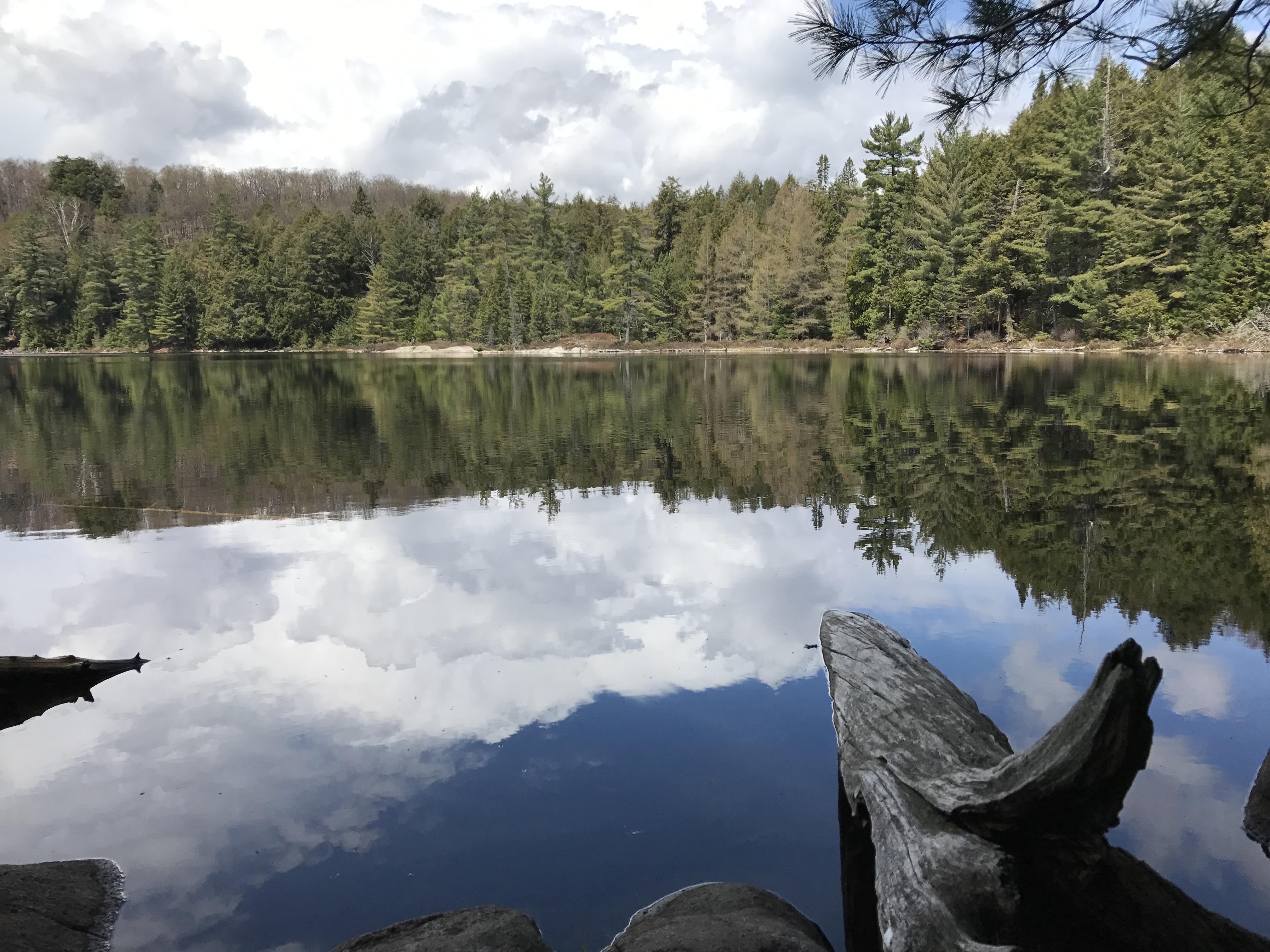
After getting our vehicle permit, we headed towards the trail in the park. Along the way, we stopped by a picturesque lake, which I believe is Smoke Lake, for some photos. It was a picture of calm and serenity, and it was simply beautiful.


At 8:20am, we arrived at the starting point of our trail. I had picked the Track & Tower trail located at km 25. The Algonquin Information Guide listed it as a 7.5km trail taking 4 hours to complete and rated it Difficult. Track & Tower is the third longest trail among the 15 trails here. I picked it because it features a scenic view of Cache Lake and an abandoned railbed. I also assessed that my parents would be fit enough to complete it.


The trail was marked by blue circular discs nailed onto tree trunks. Just follow the blue dots and you won’t be lost. After a while, it became a game of spot the dots. The morning air was super fresh and it was invigorating to hike among the greenery and be immersed totally in nature. The trail was generally easy to follow, but due to spring conditions, some sections were wet or muddy and we had to go a longer way to get around them.


We soon caught sight of Cache Lake and walked along the water’s edge. It was beautiful but the rain had come early and it started to drizzle slightly. The scenery and moody outlook reminded me of the first Twilight film.


To get to the lookout point, we climbed a steep flight of stairs, which left us a little winded. By the time we reached the top of the lookout, the weather had cleared up and blue skies had emerged from behind the clouds. We had a splendid view of Cache Lake below and the area beyond. It was definitely worth the hike up.


After descending from the lookout, we trekked for a while and reached the abandoned railway. Here, the path splits and you can go on the Old Railway Bike Trail or return to the Track & Tower Trail. We had already hiked for about 3 hours and there seemed to be still quite a way to go, so we wisely took the return trail.


The last part of the hike was quite tiring because there was not much scenery to look at, only trees. The sun was out and it was much warmer than when we first started. We were also getting hungry because it was past noon already. We kept on walking but the end was nowhere in sight.


When we finally emerged at the carpark at the end of the trail, it was 1pm. So in all, we took about 4 hours and 40 minutes to complete the hike, longer than the prescribed 4 hours. But I guess it can be done in 4 hours if we didn’t stop to take so many photos, or if we didn’t have to detour so much if the trail wasn’t so muddy and waterlogged at some parts.
We were exhausted but quite proud of our achievement, and certainly big kudos to my parents for completing it! It wasn’t easy at all, especially the steep section up to the lookout. And we also to contend with the muddy and slippery surfaces at some parts. Well done!
After we hopped back into our car, it started raining again. We drove to a nearby restaurant for lunch, but it was quite pricey so we picked another place instead. We went to the Lake of Two Rivers Café & Grill and I ordered a sandwich to recharge myself. After that, we went back to our cabin to rest. The rain was falling and it was the perfect weather to sleep in.


At about 5pm, KP and I decided to head out again for a short hike. It was still drizzling slightly so mum and dad chose to stay in. We proceeded to the Beaver Pond Trail at km 45.2. I picked this trail because it was short (only 2km) and also because I was hoping to catch sight of the beavers. When I was younger, I had read about how beavers gnaw at tree trunks to fell the trees, then use the fallen trunks as a barrier to dam up the river so as to trap fish for food. It was fascinating and I wanted to see the beaver dams for myself.


The trail took us past a pond and Amikeus Lake, both of which were created by beavers. We got to see the beaver dam up close, but unfortunately, we didn’t see any beavers. However, it was good enough.


The last part of the trail brought us to an elevated lookout point, where we had a good view of the pond below. It was a short hike and we completed it in less than an hour. Compared to the Track & Tower trail, this was much easier and manageable. It was a pity mum and dad didn’t join us for this one, as I think they would have enjoyed it.


After the hike, we went back to our cabin and KP started preparing dinner again. I told him we’d just have a simple one tonight, so he just cooked instant noodles with egg, some spaghetti, baked beans and canned soup. It was so nice to have noodles with soup in the cold weather, and I slurped up everything.

There wasn’t anything to do at night so I just chilled out while KP did some work. It had been a great day and I enjoyed the hikes immensely. If I could return in future, I would love to stay for many more days and try out all the different trails. Algonquin was my favourite part of the trip and I highly recommend it to anyone who’s visiting Ontario. You won’t regret it. End of Day 5, heading to Ottawa tomorrow!